What's happening now?
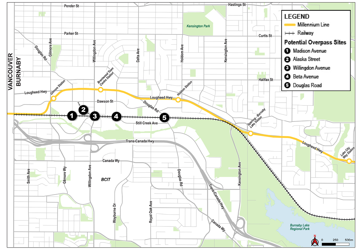
The City of Burnaby is reviewing 5 potential locations for a pedestrian and cyclist overpass across the active railway in the Brentwood neighbourhood, as identified in the Brentwood Town Centre Development Plan: Madison Avenue, Alaska Street, Willingdon Avenue, Beta Avenue, and Douglas Road. The goal is to create a network that is attractive, comfortable and safe for people of all ages and abilities.
There are two phases in this project. Phase 1 is now complete, and we thank everyone who participated in the first phase of engagement. The results are currently being analyzed. Please stay tuned for the What We Heard summary report. Phase 2, scheduled for late 2026, will share the Phase 1 findings along with draft designs for your feedback. In the meantime, if you have any questions or feedback you’d like to share, please email us at BrentwoodOverpass@burnaby.ca.
About this project
The growing population in the Brentwood Town Centre is increasing demand for transportation options, particularly the need for a sustainable active transportation network to support walking and cycling.
The City is exploring 5 potential locations for a pedestrian and cyclist overpass across the rail corridor in the Brentwood neighbourhood. These locations were first identified in the Brentwood Town Centre Development Plan and are also included in the long-range pedestrian and cycling network plans of the Burnaby Transportation Plan:
- Madison Avenue
- Alaska Street
- Willingdon Avenue
- Beta Avenue
- Douglas Road
Each location provides different opportunities to improve north–south and east–west connections between homes, schools, shops, transit, employment areas, and the Central Valley Greenway.
Our goals
As envisioned in Connecting Burnaby, Burnaby’s Transportation Plan, this project supports the City’s transportation goals by providing:
- new connections that address existing network gaps and strengthen links to local and major destinations
- diverse transportation choices so people can choose how they want to get around
- better transportation facilities so people can safely and comfortably walk, cycle and roll
- infrastructure built to serve people of all ages and abilities
- zero emission transportation facilities
How are project decisions made?
Project decisions are guided by City policies, technical requirements, and public feedback. Policies such as Burnaby Transportation Plan and Climate Action Framework provide the foundation for creating an accessible, connected walking and cycling network for everyone.
For each potential crossing location, the project team considers technical factors like:
- existing network connections and destinations served
- impacts on utilities and third parties
- environmental and geotechnical conditions
- property and construction constraints
Local knowledge and community feedback are essential. They help us understand how the network is used today, identify opportunities for improvement, and determine which evaluation criteria matter most to users.


